Hokkaistory is a digital supplement to my PhD dissertation in the department of history at the University of Victoria. It’s purpose is to collect and interpret information and narratives about the land commonly called Hokkaido, but known as Ainu Moshir in the language of the indigenous Ainu peoples. It is built around a historical gazetteer that provides a framework for the exploration of flows of information and knowledge through the landscape, during the period (c. 1860-1930) when this place was reimagined and rebuilt as part of the modern Japanese nation-state.
The gazetteer, a genre with deep roots in both Eastern and Western traditions of organizing spatial knowledge is deceptively simple, ostensibly a mere list of place names and locations, it contains and conceals within itself the powers of naming and boundary making, both key tools in the arsenals of Empires and nation-states then and now. Gazetteers, much like their close cousins maps, present a clean and orderly view of the world with a straight-forward precision that leaves little room for dispute. They contribute to a system of governance technologies that facilitate the collection, organization and dissemination of information about people, places and objects in an attempt to make them useful to processes of state and empire building, and available for capitalist exploitation. The gazetteer’s elegant simplicity helps to conceal the operation of power in this process by providing its results in harmless, bite-sized facts. Of course, the histories behind a gazetteer, the origins of the calmly asserted names and boundaries, are rarely so clean and orderly, a generalization that holds true of the places named here.
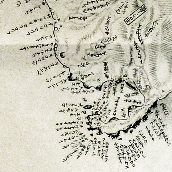
Detail of Matsuura Takeshiro, 'Tōsei Ezo yama gawa shiri torishirabe zu (East-West Ezo Mountain and River Survey Map),' Plate 4. 1858. Showing the Usu and Muroran area.
Hokkaistory is an attempt to force the gazetteer, and the technologies of governance it emerges from to account for these histories. It consists of two lists: the counties and provinces named and drawn on the map in 1869 when the fledgling Meiji state annexed the territory,[bib]1243[/bib] and the names of stations in the traditional overland transportation system, known as the Eki-tei (駅逓), or station-stop system.[bib]645[/bib] Both provide telling examples of the operation of information technology in the control and management of peoples and territories, and the reliance of these technologies on appropriations of the embodied knowledge of indigenous peoples.
The counties and provinces of Hokkaido were named based on the suggestion of the explorer Matsuura Takeshiro who travelled extensively in Hokkaido, known to him as Ezo (蝦夷), in the 1850s producing detailed maps and journals for the Bakufu government and compiling a list of nearly 10,000 Ainu language place names.[bib]1245[/bib] The county names that Matsuura proposed to Meiji leaders and then applied to the landscape were all sinicized versions of Ainu language place names. That these place names were accepted and continue in common use today offers a fruitful entry point into the space of encounter between the technologies of governance and embodied indigenous knowledge.
The station-stop system emerged from extensive networks of overland transportation routes used by Ainu hunters, traders and resource gatherers from time immemorial. At different times Japanese authorities made efforts to tie the coastal portions of these networks into a unified network that could serve as a strategic alternative to the relatively well-developed sea-based transportation system. However, in the period before 1869 viable overland transportation routes threatened the control of local trade monopolies by wealthy Japanese merchants who contracted for exclusive trade rights in each region of Ezo. The issuer of these contracts, the Matsumae warlord family, had just as little incentive to develop overland transportation, as their right to enforce a monopoly on trade depended upon the existence of ‘Northern Barbarians’ from whom the Northern Gate of the realm must be defended. Maintaining the distinction between the Japanese and foreign portions of the island was an expensive undertaking, and the inconvenience of overland travel was one asset they would not part with easily. As a result it was only at moments of crisis, when external threats turned the eye of the Shogun to the far North, that the overland transportation system was developed. In these periods, roads were built, horses were imported, and regulations were issued, but each time as the crisis passed the system ceased to function as a unit. Still, local communities absorbed the resources expended in these periods of panic, incorporating them and their embedded ideas, into wider indigenous networks of communication and transportation.
Chiri, Mashiho. Chimei Ainugo shojiten (Small Dictionary of Ainu Language used in Place Names). Tokyo: Nire Shobo, 1956.
The stations listed on Hokkaistory represent the final victory of the modern nation-state in uniting this ramshackle nest of nodes into a coherent system (at least on paper) in the 1870s and 1880s. This was of course concurrent with the introduction of rail transportation and a modern postal system that should have made this relic of mercantilist feudalism obsolete. That the Station-Stop system continued to operate alongside these two new systems into the 1920s is a testament to how deeply indigenous networks of knowledge and movement are embedded in this territory, and to the dependence of a seemingly advanced settler society upon them.
The significance of Hokkaido’s place names in preserving and asserting the presence of indigenous people and knowledge within the system of modern governance technologies has been an important thread in both the study of Hokkaido’s history, and in struggles for rights and recognition by and for Ainu people. The small group of Ainu studies scholars mentored by Tokyo Imperial University Linguist Kindaichi Kyōsuke (1882-1971), who laid the foundations of contemporary Ainu studies, made the study of Ainu place names a key component of their research, alongside the language’s structure and vocabulary, and the vast corpus of Ainu oral literature.[bib]1244[/bib]
Yamada, Hidezõ. Hokkaido No Chimei: Ainugo Chimei No Kenkyu (Hokkaido Place Names: Research on Ainu Language Place Names). Sapporo: Hokkaido Shinbunsha, 1984.
Chiri Mashiho (1909-1961), an Ainu from Horobetsu in Iburi Province, and a professor of linguistics at Hokkaido University, wrote several articles about place names in Horobetsu and other places in Hokkaido and Sakhalin Island. Much of this research was collected into a dictionary of the vocabulary used in Ainu place names[bib]1215[/bib]. Yamada Hidezo (1899-1992), a journalist, businessman, and independent scholar, focused extensively on Ainu language place names. He used Matsuura’s maps and journals, the records of other Japanese and foreign explorers, government documents, and living Ainu informants to produce a large corpus of writing on the subject, which have been collected into a four volume set still widely cited by Ainu Studies scholars today. Yamada also summarized his research as a dictionary of place names.[bib]1218[/bib] Over the past two decades the Otaru high school teacher, Sakakibara Masafumi has been independently and systematically mining these early writers’ work, as well as their sources to build a definitive GIS database of the several thousand Ainu place names existing in the archival record.[bib]1238[/bib]
Since the 1990s Ainu commuities and allies have been working to convince authorities to include Ainu versions of place names on signage throughout the Japanese controlled areas of Ainu Moshir. Despite considerable initial resistance, these bilingual signs have become common sights throughout Hokkaido, though official road sigange is still unilingual Japanese. The geologist and activist Ono Yugo, who participates in this movement, has reported that the reclamation of Ainu place names is an essential component of efforts to assert the continuance of the living Ainu presence on the land, and recover the knowledge trapped within the information collected and deployed within technologies of governance, such as official gazetteers. The Ainu Oki Dub Band, have echoed this sentiment in the video for their song “Sakhalin Rock,” which uses archival photographs and maps to highlight the dark history of cultural appropriation revealed by the layers language and text embedded in the place names of Sakhalin Island.[bib]1255[/bib] Hokkaistory is meant to build upon the efforts of all of these scholars and activists with a new method of cross-examining the technologies of governance and the information they produce.
Ainu Oki Dub Band. "Sakhalin Rock". 2010.[bib]1255[/bib]
Scholars have already developed a number of effective ways to get through and around the silences and gaps left in the information generated by technologies of governance. To generalize grossly, they either go around them to find the voices of ‘real’ people acting within and about these systems, or they read the official record ‘against the grain.’ Hokkaistory is an experiment with the latter approach. The idea is to remain true to the rhetorical constraints of the gazetteer genre. Hokkaistory preserves the limited, yet powerful voice of the officially sanctioned list, but places that voice within a new - digital, networked and critical - environment in which its silences and their functions can be heard as well. Hokkaistory then is a digital echo of its sources, a selection of statistical records and documents that were compiled and disseminated through the labour of armies of clerks and officials using a variety of technologies and information sources. But, it doesn’t aim to tell the history of these sources so much as to reanimate them. The lists of place names, and the maps demonstrate how governance technologies operate to encode and deploy indigenous knowledge. The digital environment affords the juxtapostion of a hyperlinked bibliography for tracing bits of data back to their sources, and a critical essay (in press) attempts to place the relationships between Ainu indigenous knowledge and governance within a more traditional historical narrative.
In giving attention to the form as well as the content of information, Hokkaistory draws on a number of recent works that have developed powerful ways to conceptualize the relationship between the materiality of information and the embodiment of knowledge. One important model for Hokkaistory is the Japan Meiji Gun data set compiled from data in the G.W. Skinner Archive at Harvard University.[bib]656[/bib] This data set, available for download as an ArcGIS shape file, provides detailed outlines of all the counties in Japan during the Meiji Era (1868-1912), except for those in Hokkaido. Despite being a considerable scholarly and technical achievement, the Japan Meiji Gun dataset does not claim to do more than simply show where county boundaries were placed on the surface on the Earth. It does not engage with or critique its sources, or the historical processes that generated these boundary lines. At its most basic level Hokkaistory completes the Japan Meiji Gun project by providing accurate information about Meiji Era county boundaries in Hokkaido in a variety of data formats, but it also goes further by trying to demonstrate and explain something of the history of these boundaries.
To this end Hokkaistory draws upon the critical trend in the study and practice of cartography that was kicked off by J.B. Harley’s seminal article “Deconstructing the Map.”[bib]1247[/bib] Harley used Derrida’s methods of textual deconstruction and Foucualt’s notion of biopower to critique the tendency of geographers to take the claims of modern cartography to verisimilitude and objectivity at face value, and argued that maps participate, as do all texts, in the operation of power structures. Matthew Edney built upon Harley’s ideas four years later with an attack on the meta-narrative of progress in the field whereby the history of cartographic practice became nothing more then the story of the progress of mathematical perfection in the scaled representation of the Earth’s surface. Edney pointed out how this narrative favoured maps created in a single European cartographic tradition, mostly since the enlightenment, with a few earlier prototypes thrown in, while ignoring and denigrating other practices of spatial representation that did not contribute to this arc of progress.[bib]1239[/bib] The maps created and reproduced for Hokkaistory can certainly be read into this narrative of scientific and technological progress. Indeed the history of the cartography of maritime North East Asia is still most often framed around the brave Western and Japanese explorers who pushed against the darkness to reveal the riches of these mysterious territories. Hokkaistory though, aims to shift the frame to show the increasing technical sophistication of spatial representation not as a generalized and natural advance of knowledge, but as a specific example of the exercise of technologies of governance through the appropriation of local embodied knowledge. At the same time, by pointing to areas where appropriated voices seem to seep through the fabric of the official information networks, it tries to show how these techniques, like all human endeavours, are not perfect, thus revealing the contested and contingent nature of these apparently transparent representations of reality.
Wigen, Kären. A Malleable Map: Geographies of Restoration in Central Japan, 1600-1912. Berkeley: University of California Press, 2010.
Another key inspiration for Hokkaistory is Karen Wigen’s extension of ‘poetics’ to a reading of early Japanese Fūdoki (風土記), or gazetteers, and their modern counterpart the official statistical book, (pg. 141).[bib]1221[/bib] In her study of the historical geography of Shimano Province, Wigen explains that rather than deploying the usual quantitative methods of evaluating these types of sources she has tried to understand them as a literary critic who is less interested in the details of a single poem as in the ‘way poetry works.’ For Wigen then gazetteers and statistical records are not mere collections of facts, but tools for ‘dissecting and displaying the countryside,’(pg. 141). From this perspective the order and arrangement of the information and the affordances they present to the reader for ‘seeing’ and utilizing the places represented become the most significant aspects of these documents. In particular, she identifies the gazetteer’s ability to provide a linear overview of a territory that can be zoomed into to provide access to specific features of the individual places listed. The power of this method comes in tracing how these information tools cut across lines of political and cultural conflict within the spaces they represent. Hokkaistory follows Wigen’s lead, first by using the added affordances of the digital environment to make the overview and details of the state’s eye-view visible and vulnerable to examination and exploration.
The official place names imposed upon the portion of Ainu Moshir dubbed Hokkaido by the Meiji government in 1869 are just such an area of seepage, where the straight forward narrative of development and progress is stained with something older and incongruous. Hokkaistory approaches this region from within the perspective of technologies of governance by collecting and reproducing in interweaved layers the overviews and close-ups afforded by a small set of gazetteers and maps, organized around two lists: the county names suggested by Matsuura and adopted by the Meiji government in 1869[bib]1243[/bib], and the list of Staion-Stop Stations in the Ministry of Finance’s 1885 "Report on the Activities of the Katakushi[bib]645[/bib]". The first layer of abstraction from these lists is a visualization of the bird’s eye view that these lists imply (Maps A-F), supplemented with the beginnings of a catalogue of the conflicts and contradictions embedded within the lists in the form of an historical narrative.
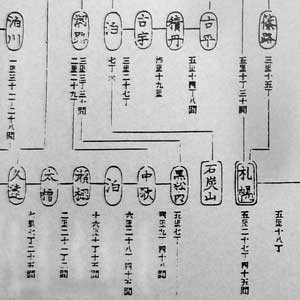
Detail of the Graphic representation of station stop stations in Ōkurashō (Ministry of Finance). “Kaitakushi jigyō hōkoku (Reports of the Activities of the Kaitakushi).” Vol 4. Government of Japan, 1885, 8.
Finding accurate locations and boundaries for the 89 counties and 164 Station-Stop Stations required consulting a very large number of historical maps and gazetteers. Fortunately, the Northern Studies Collection at the Hokkaido University Library very graciously allowed me to create high-resolution digital reproductions of their extensive collection of maps. Once georectified these maps were scoured and compared to generate the points and polygons that place the listed place names on a digital projection of the Earth’s surface. A selection of these historical maps have been made available for comparison and exploration (Maps G-N). Another major challenge was accounting for changes in boundaries and place names over time. Originally, the goal was to represent the county system up until 1945, but the complexity of the changes forced a limitation of the scope of the visualization. The gazetteers and maps then, are organized into two snapshots between which the county boundaries were fairly stable. The first snapshot shows county boundaries and station-stop stations in 1869 immediately after the imposition of the county system and the establishment of the Kaitakushi (Development Comission) to administer the territory. The second snapshot is in 1885, three years after the ignominious abolition of the Kaitakushi and on the eve of the establishment of a new prefectural government (Hokkaido-Chō) with a mandate for aggressive settler colonialism and capitalist exploitation. The changes in place names and boundaries between these two snapshots are visible on the overview maps as well as within the detailed views of the affected places, which can be accessed from the gazetteer lists, or by clicking on the individual places on the map. The beginnings of a second layer of abstraction appear in the form of map layers that display statistical information produced by Kaitakushi and Hokkaido-Chō on the birds-eye view of the lists. These layers illustrate the interconnections among various types of information produced by governance technologies with the framework provided by the list. They also point to the possibility of further research that builds upon the foundational geographic data presented by Hokkaistory to address a variety of interesting historical quuestions, (Maps O-S). Finally, the essay will provide a third layer of abstrastion, by trying to explain the workings of this technical poetry, by making explicit connections between the affordances of maps and gazetteers and the appropriation of indigenous knowledge, but by no means exhausting the possible readings and critiques that might emerge from this small collection of official voice.
There is a danger in relying so heavily on government sources that their voice will be internalized and the knowledge contained within reappropriated. The other portion of my dissertation attempts to balance this risk with a close look at the agency of Ainu actors and allies within this period of transition into a modern nation-state centred information ecosystem. Here though, I rely on the fluidity and capacity of digital infrastructure to reanimate nineteenth century technologies and reveal something of their inner workings. It is important to tread carefully however, because though we are still in early days, our new digital toys are quickly settling into forms and conventions that favour the centralized control and management of people, places and ideas on greater scales than ever before. Accessible and powerful cartographic technologies, exemplified by Google Earth, but also including the open source OpenLayers code library used by Hokkaistory, are direct descendants of the nineteenth century tools under examination. They represent the culmination of the old narrative of ever greater precision and control in representing the surface of the Earth. In Google’s vast databases we might see the realization of the wildest dreams of the rulers and officials who dispatched explorers on perilous missions in the hopes of seeing and controlling people and objects in far-flung locales.
On the other hand though, much has been made of the distributed nature of digital technologies and their potential to allow people to communicate in non-hierarcical networks that can destabilize and even replace centralized systems of governance and control. Just in the decade since the deployment of mass social networks we have seen a great deal of destabilization within institutions developed in the analog world, including within the academy on whose foundations Hokkaistory depends. Still, it is not clear that these destabilizations will result in significant long-term changes to the distribution of knowledge and power, nor whether these changes, if registered, will bring people together or further fracture and divide them.

Liu, Alan. The Laws of Cool: Knowledge Work and the Culture of Information. Chicago: University of Chicago Press, 2004.
Hokkaistory doesn’t claim to offer a solution to this impasse, but instead to embody and extend this moment of chaos and uncertainty. It is a response to Alan Liu’s call for humanities scholars to take on the role of ‘ethical hackers of knowledge work’ in a world where all knowledge is rapidly converging into a single paradigm of information production and processing that isolates ‘content’ from its history, (pg. 7-8).[bib]1226[/bib] Hokkaistory, then is an attempt to ‘sample, appropriate, deface, and hack what is most valued in knowledge work – the content, form, and control of information,’ in order to ‘construct, or reveal the illusion of the eternal now and the self-evident presence of information,” (pg. 7-8).
There are multiple targets. Using digital mapping tools and databases to reanimate nineteenth century technologies of representation connects both in a continuing narrative of the control and appropriation of local embodied knowledge. At the same time, remixing old and new information technologies as a way to critique contemporary narratives of history also challenges the dominant forms and controls placed on the production of information by academic institutions and structures, (more on this within the technical discussion). These two however, are merely targets of opportunity. The main targets are those nineteenth century appropriations of embodied Ainu knowledge that helped to deface and neutralize a complex and effective system of technologies that supported free and autonomous human life for many centuries before the state arrived in Ainu Moshir. Hokkaistory cannot hope to recover these lost voices, but it can, and does, use the very tools of appropriation to call to account those processes, or ‘dark histories’ through which they were stolen and made to serve the creation of a new world, (pg. 8)[bib]1226[/bib].